The Two-Dimensional Hydrodynamic Analysis of the Moose Creek Floodway was a joint effort performed by both the Coastal and Hydraulics Lab at the Engineering Research and Development Center at (ERDC-CHL) and the Alaska District Corps of Engineers (POA). A two-dimensional hydrodynamic model using Adaptive Hydraulics (AdH) was developed for simulating the hydrodynamics. The AdH model, was developed at the ERDC-CHL, with model improvements continually being implemented through on-going research programs.
The Moose Creek Floodway is located approximately 17 miles East of Fairbanks Alaska. The floodway is part of the Chena River Lakes Flood Control project which was authorized in 1968. It consists of three main features; the Moose Creek earthen dam which regulates Chena River flows to downstream Fairbanks, a floodway for re-directing excessive flood flows (>12,000 cfs) to the Tanana River, and a levee system along the Tanana River.
The Chena River floodway is designed to reduce the flood risk at Fairbanks, AK by re-routing flood flows through the floodway into the Tanana River. When the Chena River floods above the Moose Creek Dam water enters the floodway and flows parallel to the dam 6.7 miles to the floodway control sill adjacent to the Tanana River. The floodway control sill is designed to prevent backwater from the Tanana River from entering the floodway. The dam is an earth filled structure designed to contain short duration floods. As is the case with all earthen dams, it is subject to stability issues such as seepage and piping flows due to the hydraulic gradient across it. To reduce the potential for dam failure during a flood, the optimal floodway design condition is to reduce the water surface elevation along the dam. Controlling factors for the head on the dam are; floodway channel surface roughness, channel constrictions due to the highway and railroad bridge crossings, and the elevation of the downstream control sill.
The Modeling effort consisted of three main goals. The first goal was to develop a two-dimensional floodway model that could be efficiently executed on a personal computer (PC). The second goal was to investigate the impact of highway and railroad bridge piers on floodway water surface profiles during flood conditions. Finally, the third goal concentrated on optimizing the model for predicting impacts of floodway vegetation and Tanana River stage on backwater profiles. The ERDC-CHL completed the first two goals of the study, while for the third the District engineers developed a detailed vegetation roughness map of the floodway and added a segment of the Tanana River to the model. The final optimized model was then used to evaluate backwater profiles for the probable maximum flood (PMF).
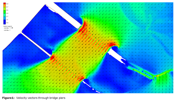
All three project goals were met and exceeded for project completion. First, an efficient AdH personal computer model was developed for the Moose Creek floodway. This Base model serves as management decision/support tool for the district, such that rapid changes can be made for Floodway evaluations. Simulation times for the ERDC-CHL base model ranged from 2-4 hours for the five day PMF hydrograph simulation. The ERDC-CHL base model results compared favorably to a physical model results, a historic study previously conducted by ERDC-CHL, in terms of flow velocity between the bridges and water surface elevation from the sill to just above the highway bridge. Next, in a highly refined mesh with 2.5 ft elements for resolution around the piers, the head loss due to the combination of the resistance of the bridge pilings and a more detailed upstream extension was run on the ERDC HPC. These modifications to the base generated approximately 0.2 feet of increased backwater upstream of the piers for the PMF peak flow. This was the first time the pier impacts, shown in Figure 1, had been modeled for the floodway. Previous work had ignored them due to the necessary resolution, associated computational burden, and model limitations. Finally, the addition of the Tanana River segment along with a detailed vegetation roughness map to the Floodway model provided a more realistic simulation of system hydrodynamics and overflow pathways than previous model studies. The generated ERDC-CHL/POA model for the Moose Creek Floodway is a validated and holistic representation of the system at a level of refinement never before achieved.

For more information, contact the project lead, Jeremy Sharp, U.S. Engineer Research and Development Center (ERDC), Coastal and Hydraulics Lab (CHL) at: