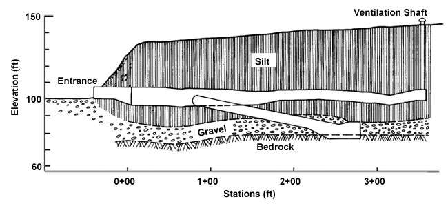
The schist bedrock is overlain by six to eight feet layer of gravel, called the Fox Gravel. The gravel was derived from the bedrock in the area and deposited by solifluction and then reworked by streams. During the creation of the gravel layer, local lode gold deposits were eroded and carried downstream by creeks, where the gold was eventually laid down with the gravels in placer deposits. In the vicinity of the tunnel, the gravels and gold were deposited by Goldstream Creek across the width of the valley due to the meandering nature of the creek. Felix Pedro discovered gold in 1902 north of Fairbanks, Alaska, and since then to the early 1960s, a significant portion of the gravels have been reworked by miners.
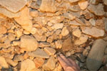
The Fox Gravel is sub-angular to rounded and measures up to 6 inches in length with woody fragments. The Fox Gravel is thought to be deposited in late Pliocene (2.5 to 3 million years before present). However, woody remains in the top layer gravels within the tunnel are dated to between 43,000 to 46,000 before present. The time difference suggests reworking of the gravels prior to the silt deposition. The photo shows the gravels within the tunnel which are cemented together by ice.

Diagram from U.S. Army Corps of Engineers Cold Regions Research and Engineering Laboratory (1981) CRREL permafrost tunnel. CRREL Benchnotes 17: 1-7. Hanover, NH: Cold Regions Research and Engineering Laboratory.
Overlying the Fox Gravel is a thick layer of silt called the Goldstream Formation which was mostly deposited during the Wisconsin Glaciation (30,000 to 10,000 years before present). The Goldstream Formation is overlain by a thin silt layer called Ready Bullion Formation and was deposited from the start of the Holocene at 10,000 years before present to about 3,500 years before present. Both silt layers are windblown silt or loess that has been retransported by stream action. The retransported silt contains a higher volume of ice and organic material than the wind-deposited silt, and upon thawing it becomes very wet mud with a rotting-like smell that led to the nickname of the muck.

Deposits of rocks within the tunnel. |

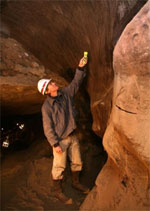
Ice wedge in the winze. |
During the past ice ages, the Fairbanks area was a periglacial environment, where it was surrounded by glaciers but not directly covered by ice. The glaciers provided the silt that was windblown into the area and the cold environment allowed syngenetic permafrost to grow. The windblown silt is mainly derived from the Tanana River floodplain which contains washout from the Alaska Range south of Fairbanks. There is evidence that some loess inclusions are windblown derivations from the Yukon and Nenana Rivers. The regional loess was deposited during times of glaciation and interglaciation, and still today loess is collecting in the Fairbanks area. The loess thicknesses in the area varies from 4 to 80 feet on the low slopes of hills and tapers off on the upper slopes at an elevation of about 1000 feet above sea level. Retransported loess has moved some higher elevation silt to lower elevations resulting in thicker layers in the valley bottoms up to 360 feet in thickness. In 1987, a dust storm from the Tanana River Floodplains was observed at the University of Alaska Fairbanks and air samples were collected. During the dust storm, the wind was about 30 mph and the dust concentration was 5,100 particles per cubic foot. Intriguingly, the measured dust concentration that is regularly within the air, not during a dust storm, is 60 to 1,700 particles per cubic foot. If the climate is cold enough to create permafrost as this dust deposits on the ground surface, it will eventually create syngenetic permafrost as seen within the two silt formations in the tunnel.
The frost actions associated with syngenetic permafrost create many cryostructures that are visible in the silt of the Tunnel, such as ice wedges, segregation ice, and thermal erosion ice known as thermokarst-cave ice. These structures are encountered in all regions of the world where permafrost exists, but they are most prevalent in frozen fine-grained soils. The photo to the left shows an example of one of the ice wedges within the Goldstream Formation.
The Goldstream Formation has long thought to have undergone climate change periods and reworking, one example being the two sets of ice wedges have been observed in the Permafrost Tunnel. The first and lower set ranges in age of about 25,000 to 33,000 years before present and are larger than the second set. The second and upper set ranges in age of about 10,000 to 14,000 years before present. These two separate ice wedge units suggest that a warming period thawed the permafrost before deposition of the overlying second set. The warming period has been termed the Fox Thermal Event. Near the tunnel entrance exists a large amount of colluvium that was deposited after a thermal erosion event removed the silt. The debris consists of gravel, sand, and silt along with bones, grasses, and wood fragments. The flora and fauna remains are abundant in this section, especially with large vertebrates or megafauna (mammoths and bisons) with Bison bone being dated from approximately 10,000 to 14,000 before present. In addition, viable living bacteria was collected from the first set of ice wedges and dated to be 25,000 years before present.
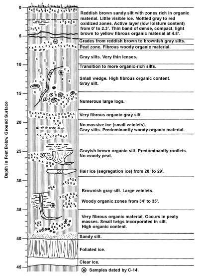
The depth of the tops of the second and upper ice wedge set, with their corresponding ages, are not really known. The only encounter with the tops of these ice wedges was a small ice wedge that was briefly seen within the ventilation shaft shortly after the tunnel was constructed. The diagram showing geology of ventilation shaft is drawn by Paul Sellmann in 1967, where the asterisks mark carbon dating samples. The significance of the tops of ice wedges is that it is known through the region as the boundary between the Goldstream Formation and the Ready Bullion Formation at about 10,000 years before present. The Ready Bullion Formation differs from the Goldstream Formation by having large wood pieces and no large ice wedges. In the diagram, the second asterisk from the top was dated to about 8,500 years before present, and was assumed to be the top of the ice wedges at the time. However, the assumption is probably incorrect with drawing depicting more of an ice vein than a full ice wedge, and therefore not the Goldstream and Ready Bullion Formation boundary. In addition, below the ice vein are numerous large logs that are commonly identified with Ready Bullion Formation. The boundary is more likely just above the large ice wedge drawn at 25 feet at the third asterisk below the top, however the carbon dating at that point was bad with a date of about 2,500 years before present. The top of this ice wedge is the only documented unaltered ice wedge top at the tunnel, therefore it may not mark the exact depth of the boundary.

Diagram from Sellmann, P. V. (1967) Geology of the USA CRREL Permafrost Tunnel Fairbanks, Alaska, CRREL Technical Report 199. Hanover, NH: U.S. Army Cold Regions Research and Engineering Laboratory.