Permafrost: General Facts

Permafrost (n)—The technical definition is soil and/or rock that has remained below 32°F for more than two years, regardless if significant amounts of ice exist or not.
Collapse All Expand All
 Permafrost Zones

Continuous permafrost is found in very high latitude regions, where permafrost exists uninterrupted both vertically and horizontally with a few exceptions like under bodies of water. In Alaska, continuous permafrost begins generally at the latitude of the Brooks Range.

Moving south from the continuous permafrost zone towards latitudes with no permafrost, there is the region of discontinuous permafrost. Discontinuous permafrost is where permafrost only exists in certain areas depending on the vegetation, soil type, moisture, and exposure to solar radiation. The percentage of permafrost coverage varies from 90% to sporadic or isolated patches. Fairbanks, Alaska, and the Permafrost Tunnel are in the discontinuous permafrost zone.

Mountain or alpine permafrost exists at high altitudes in low latitude regions, where the cold mountain air temperatures can support permafrost in a region that does not have permafrost at low altitudes. Subsea permafrost exists on the continental shelves in the arctic seas. This permafrost was formed when the sea-levels were lower during large glaciations. Due to the concentration of salt in the water, which lowers the freezing point to approximately 28°F, the now higher sea levels do not thaw the permafrost.

Diagram of the geologic hazards of the Fairbanks area.
Diagram by Péwé, T.L. (1982) Geologic hazards of the Fairbanks area: Alaska Division of Geological &l Geophysical Surveys Special Report 15, 119 p. (Public Domain)
 Temperature Profile
Ground temperature profile. The diagram illustrates a simplified ground temperature profile of permafrost. As the air temperature oscillates between cold and warm, the ground temperature will reflect these temperature changes to a certain depth and with a lag in time. The minimum and maximum temperature the soil obtains forms a trumpet curve that intersects at the depth of zero amplitude, where annual temperature variations cease. The geothermal gradient is the warming that comes from the center of the earth, which is approximately 1.5°F per 100 ft. The geothermal gradient defines the curve's slope in between the depth of zero amplitude and the bottom of the permafrost. Overlying the top of permafrost, or permafrost table, is the active layer. This top portion of ground thaws during the summer and refreezes during the winter. For non-permafrost areas, the active layer is the top portion of ground that freezes during the winter and re-thaws during the summer, it is also known as the seasonal frost layer. On the diagram, the depth of the active layer is where the maximum temperature intersects the vertical 32°lF line, meaning that is the depth where the permafrost thaws to during the summer.

For Fairbanks, Alaska, the typical active layer depth is 2.5 feet and the typical permafrost thickness is 150 feet, however both vary depending on the local conditions. The average permafrost temperature is about 31°F, and this is sometimes termed "warm permafrost" because it is very close to the thawing point.

The profile diagram is simplified and exaggerated to show detail. Due to fluctuating climates, or a body of surface water, the permafrost could have an unfrozen layer or talik in between the active layer and the top of the permafrost. During a climate change event, the curve between the depth of the zero amplitude and the bottom of the permafrost could be in non-equilibrium and curved for a period of time until equilibrium readjusts by thawing or freezing of the top or bottom of the permafrost.

 Epigenetic Versus Syngenetic Permafrost
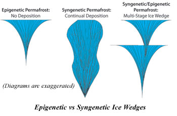
Diagram of syngenetic ice wedges. Epigenetic permafrost is formed in soils already has been deposited by wind, water, and/or gravity through the thousands of years of geological action, and after are subjected to a colder climate causes freezing and creates permafrost. Syngenetic permafrost is the process where soil freezes and becomes permafrost occurs as the soils are being emplaced by wind, water, and/or gravity. The segregate ice and other ice features that are created at the base of the active layer can become captured and will then exist through out of the depth of the syngenetic permafrost layer. With epigenetic permafrost, the ice features will be concentrated at the top portion of the soil layer.

Ice wedges, in epigenetic permafrost, will have a typical wedge shape as seen in the diagram. In syngenetic permafrost, ice wedges will have an atypical shape. With syngenetic permafrost, if the deposition is continual and without large climate change events, the ice wedge will elongate as the top of ground surface and permafrost rises. If the deposition varies with pace and/or the climate changes for a period of time, the ice wedges will look truncated and stacked, and is termed multi-stage wedges in the diagram. For example, imagine an ice wedge developing during a cold, steady depositional period, and then a climate change event happens where the ice stops growing due to warming. This event will truncate the ice wedge, and when conditions returns to cold another ice wedge will start to develop. The diagrams are exaggerated and simplified, where actual ice wedges will not look perfectly shaped as cracking does not happen in the center of the wedge every time. The tunnel primarily contains syngenetic ice wedges, where for several the type is unknown. Several ice wedges are multi-stage looking ice wedges. However, the ice wedges are truncated by a thermal erosion event that took out the tops of the ice wedges, or possibly the centers of a large continual deposition ice wedges. The top portions of the ice wedges cannot be seen within the tunnel, so it is unknown which type of syngenetic ice wedge it is.

The Permafrost Tunnel contains syngenetic permafrost. Due to the syngenetic nature of the permafrost makes the tunnel a time capsule throughout the last 40,000 years. The deposition of the soils through wind and water action was very slow, and through out this time flora and fauna existed on the ground surface. Eventually the flora and fauna were buried and incorporated within the permafrost where it has been kept frozen ever since. There are many exposures of bones and plants along with ice features in the tunnel that can tell us a lot about the past climate and its changes through the last 40,000 years.

 Frost Actions
Virtually all of the features within permafrost are due to frost actions. As an example, segregated ice forms as the freezing front moves downward through the soil and draws water to it. The ground can become so cold causing it to contract so much that the ground will crack to relieve stress, this eventually leads to the formation ice wedges. Seasonal freezing and thawing will also create a variety of patterned ground. After the soil is completely frozen, there are very few natural processes that will continue to create features. The freezing and thawing process generally must occur to mold or shape the soil or terrain.
 Permafrost Thaw-Stability

Coarse-grained soils, such as gravels, are non-frost-susceptible, meaning they do not form significant segregated ice and frost heave. This also means that permafrost coarse-grained soils generally do not have high percentage of ice. Because of the lack of segregated ice formation, the individual soil grains will generally remain intact with one another after the freezing process. When these soils thaw, the soil grains will have little or no distance to travel until they are in contact with each other. Therefore, the soil will have minimal settlement and keep their foundation strength.

Fine-grained soils, such as silt and clays, are frost-susceptible, and meaning they form segregated ice, if water is present, and frost heave. The soil frost heaves because the forming ice lens pushes the soil grains relatively far apart, the amount of frost heave is generally dependent on the amount of water that is available. When these soils thaw, the soil grains must travel large distances to become in contact with each other again. Therefore, the soil will have large thaw settlements that are often not uniform throughout an area. In addition, the thawing soils will release the previously frozen excess water which will saturate the soil forcing it loss much of its foundation strength. However, if the fine-grained soils had no access to water when freezing, the permafrost formation will be dry and when thawed will generally have minimal settlement.

References for This Page

 References

Davis, Neil (2001) Permafrost: a guide to frozen ground in transition. Fairbanks, AK: University of Alaska Press.

Kanevskiy, Mikhail, Daniel Fortier, Yuri Shur, Matthew Bray, and Torre Jorgenson (2008) Detailed cryostratigraphic studies of syngenetic permafrost in the winze of the CRREL permafrost tunnel, Fox, Alaska. In Vol. 1 of Proceedings of the Ninth International Conference on Permafrost: University of Alaska Fairbanks, June 29–July 3, 2008, ed. D.L. Kane and K.M. Hinkel, 889–894. Fairbanks, AK: Institute of Northern Engineering.

Péwé, T.L. (1982) Geologic hazards of the Fairbanks area: Alaska Division of Geological & Geophysical Surveys Special Report 15, 119 p.

van Everdingen, Robert, ed. 1998 revised May 2005. Multi-language glossary of permafrost and related ground-ice terms. Boulder, CO: National Snow and Ice Data Center/World Data Center for Glaciology.